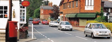


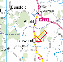
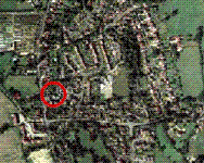
The Village |
The Village of Loxwood lies in the Northwest of Sussex very close to the border with Surrey Click on the map to see where the Village is or
|
||
 |
 |
|
A SHORT HISTORY OF A LOXWOOD
Loxwood is part of the “Low Weald” a once heavily wooded area of Sussex.
Records of the village stretch back to the time of the Knights Templar,
with the earliest mention of “Lokeswude” being from 1248. The name “Loxwood” has its roots in Old English,
“Lox” comes from the Celtic word meaning “winding stream”
and “wood” originates from “Weald” which was Anglo-Saxon for forest.
The history of the village has been formed around the river “Lox”, its first chapel which was built in 1404,
its ancient water mill, farms, agriculture, and the Wey and Arun Junction Canal which opened in 1816
as a vital trade link between London and the South coast.
The canal brought prosperity with businesses, shops, the first school and a new village church all being built,
however it was abandoned in 1871 with the coming of the railways.
In 1971 on the 100th anniversary of that closure,
a group of enthusiasts had the idea of trying to reopen the redundant waterway,
using just volunteers and charitable funding, and incredibly their vision was fulfilled in 2009
when the first canal boat sailed under the new Loxwood Canal Bridge into the Loxwood lock.
The village has 53 listed buildings some dating back over 600 years and the fascinating 750-year history
can now be discovered on our new website,
which explains how Loxwood developed from uninhabited, marshy woodland to the vibrant,
modern, picturesque village of today.
There is also a Loxwood History Website which can be found at loxwoodhistory.co.uk